West Yorkshire Mass Transit: Spatial Development Framework Joint Development Plan Document (DPD) Consultation

Details have been forwarded by Leeds City Council to inform residents about its latest consultation relating the Leeds Local Plan, specifically the West Yorkshire Mass Transit: Spatial Development Framework Joint Development Plan Document (DPD).

The Leeds Local Plan is made up of several documents that guide how land is used across the district, such as where new homes, jobs and services should be located. Leeds City Council has been working closely with the other West Yorkshire Local Planning Authorities (Bradford, Calderdale, Kirklees and Wakefield) and the West Yorkshire Combined Authority (WYCA) to prepare a West Yorkshire Mass Transit: Spatial Development Framework Joint Development Plan Document (DPD)

This draft Spatial Development Framework sets out a shared, West Yorkshire?wide approach to planning around current and future Mass Transit routes. It aims to support better transport options, regeneration, and well?planned growth across the region.

Once adopted, it will form part of the Development Plan for all five West Yorkshire Local Planning Authorities.

We are now inviting comments as part of the Regulation 18 consultation.  The consultation period runs from Thursday 29 January until 23.59 on Thursday 12 March 2026

 What This Consultation Covers

The consultation focuses on broad policy areas that relate to Mass Transit corridors, including:

  • How development around transit routes and stations should be planned
  • Where new homes and jobs could be focused
  • Placemaking and design quality
  • Supporting walking, cycling and public transport
  • Protecting the environment, addressing climate change and managing flood risk
  • Ensuring consistent, joined-up planning policy across West Yorkshire
  • A criteria?based approach to safeguarding land needed for future Mass Transit infrastructure

 What This Consultation Does Not Include

  • Specific site allocations for housing, employment or mixed-use
  • Local or strategic Green Belt changes
  • Detailed safeguarding of routes for Phase 1 or later phases
  • Changes to district growth targets
  • Replacing Local Plan policies (this plan forms a high-level strategic layer only)

 How to Get Involved

This is the first stage of the consultation (known as Regulation 18). We are keen to hear from communities across the Leeds district on the scope and content of the Spatial Development Framework Joint Development Plan Document.

Residents can view the full consultation materials and share your comments in the following ways:

This Issues and Options consultation is open until 23.59 on Thursday 12 March 2026.

Additional Information

Further details on how to respond and where to view documents are set out in the enclosed Statement of Representation Procedure.

The consultation will be carried out in accordance with the Statement of Community Involvement.

Frequently asked questions (FAQs) | West Yorkshire Mass Transit: Spatial Development Framework Joint Development Plan Document Regulation 18 | Your Voice

Next Steps

Unless you tell us otherwise, we will keep you updated about future stages of the Spatial Development Framework, including further opportunities to comment. Please note:

  • All comments will be published (including online) as required by regulation.
  • Your information may be shared with the five West Yorkshire planning authorities, WYCA, and specialist advisers supporting this work.
  • Anonymous comments cannot be accepted.
  • Feedback will be anonymised in published summaries.

If you have questions, require materials in another format, or need help responding, please contact WYCA:

Telephone: 0113 245 7676 (Metroline – charged at the standard operator’s rate) or

Email: MassTransit@westyorks-ca.gov.uk

Alternatively, you can contact the Leeds Local Plans team, Email: localplans@leeds.gov.uk

Roadworks A659 Pool Road – 2nd Feb until 13th Feb 2026

The following roadworks will take place between 2nd February and 13th February 2026

  1. Pool Road Junction at New Development:
  • Works are required to improve the footway due to an ongoing invasive weed (horsetail) issue.
  • Starting Monday, 2nd Feb 2026 for 2 weeks until Friday, 13th Feb 2026.
  • 30am – 3.30pm under three-way lights. No traffic diversions are required.

    2. Pool Road – Mini Roundabout:

  • Short-term traffic management required to modify lane designation markings. This element of the work will be completed quickly but is weather dependent.

Notes:

  1. In both work areas, emergency access and pedestrian access will be maintained at all times.
  2. Advance Warning signs with dates and times will be installed prior to work commencement.

Arthington Road – Temporary Road Closure

Leeds City Council wish to notify residents that there will be a temporary road closure on Arthington Road from 7pm on 3rd February 2026 to 5am on 4th February 2026 in order for works to take place to remove trees infected with Ash Dieback

The closure will affect Arthington Road, Leeds between its junctions with Kings Road and
Kings Lane, and then between its junctions with Bank Top Lane and Black Hill Lane.

A diversionary route for vehicles affected by the closure will be available via:
Arthington Road, Black Hill Lane, Eccup Lane, King Lane and vice versa for the closure between Kings Road and Kings Lane; Kings Road, Leeds Road, Pool Bank New Road, Arthington Lane and vice versa for the closure between Bank Top Lane and Black Hill Lane.
Essential access to and from premises and for emergency vehicles will be maintained.

Royal British Legion Bramhope Quiz Night  – 7th March 2026

Royal British Legion Bramhope Quiz Night

Quiz Night Royal British Legion 2026

The Bramhope branch of the Royal British Legion are hosting a quiz night on Saturday 7th March 2026 at West Park Leeds RUFC, Bramhope. The Sycamores, Bramhope, Leeds LS16 9JR.

Doors will open at 7pm with the quiz starting at 7.30pm.

The entry fee will be around £3 per entry with maximum team size permitted will be six.  Solo entrants are permitted

There will be a prize for the winning team.

A raffle will be held, with prizes including tickets to a show at Leeds Playhouse, afternoon tea voucher for two at Crag House Farm, fee food membership to the Rudding Park Foodies club.

There will be additional fun games for the evening in-between quiz questions which will be £1 per go.

If you would like to reserve a table email sophiehannahlouise777@gmail.com

All funds raised will be for the Poppy Appeal.

All are very welcome to come along and enjoy the evening.

Planned Electrical works, Main Street, Pool to commence Monday 9th January

Works to create essential new electrical supplies to, Stanhope Fields Development off Pool Road, Pool in Wharfedale will necessitate some works on Main Street, Pool

In order to carry out the works safely there will Multiway signals in use at the junction with Church Lane, and where possible this will be restricted to 0930 – 1500hrs, if all goes to plan, it is expected on the 14th January, the lights will be in use for the full day

The works are due to commence at 0930hrs Friday 9th January and expected to be complete by 1500hrs Sunday 18th January and the lights will be manually operated at all times with 2 Operatives to ensure maximum flow is maintained

The location of the works is shown at https://one.network/?GB146899392

Have Your Say on Police Funding 

West Yorkshire residents are being asked to share their views on police funding for 2026/27.

A short survey is now open about the police precept – the part of your Council Tax that helps pay for policing across our region.

The proposed change would mean an extra 19p–26p per week for most households in Council Tax Bands A to C.

Council Tax Band | Current Cost per year (£) | Annual Increase (£) | Per Week Increase

·  A | 175.52 | 10.00 | 0.19

·  B | 204.77 | 11.67 | 0.22

·  C | 234.02 | 13.33 | 0.26

·  D | 263.28 | 15.00 | 0.29

·  E | 321.78 | 18.33 | 0.35

·  F | 380.29 | 21.67 | 0.42

·  G | 438.80 | 25.00 | 0.48

·  H | 526.56 | 30.00 | 0.58

The consultation closes at midnight on 20 January 2026.

? Have your say now by click on this link and filling in the survey: www.yourvoice.westyorks-ca.gov.uk/police-precept-26-27 

ROAD CLOSURE INFORMATION – Leeds Marathon/Half Marathon 10th May2026

Run For All have sent advance notice of the Rob Burrow Leeds Marathon/Half Marathon taking place on Sunday 10th May 2026 and the road closures being implemented around the city to accommodate this.

Event Specific Information

Date: 10/05/2026

Leeds Marathon Start Time: 09:00

Leeds Half Marathon Start Time: 10:00 (Subject to change)

Last Runner expected to Finish: 16:45

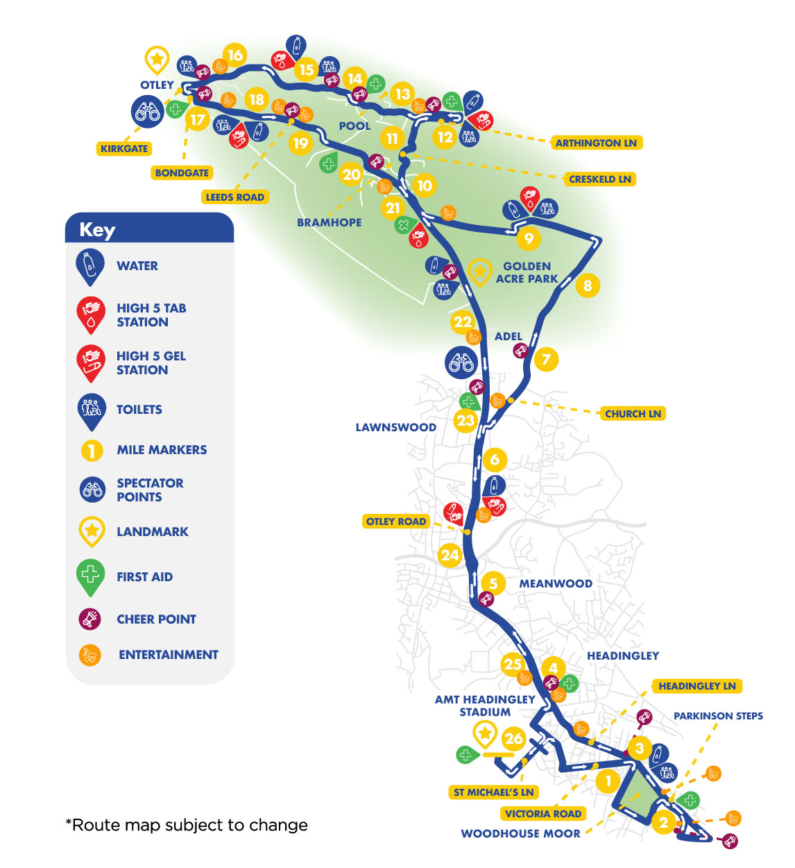
Leeds Marathon Route: https://www.runforall.com/media/me3fxx04/leeds-marathon_route-map.jpg

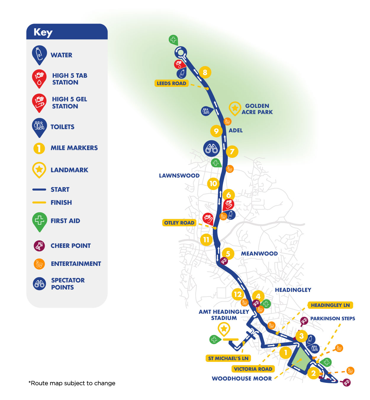
Leeds Half Marathon Route: https://www.runforall.com/media/l54gtuyu/leeds-half-marathon_route-map.jpg

Leeds Marathon Route Specifics

The 2026 Leeds Marathon will start on St Michael’s Lane and finish inside Headingley Stadium. The route will head out via Cardigan Road, Victoria Road and loop around Woodhouse Moor towards Leeds city centre. Runners will then complete a loop by Leeds University before using Otley Road (towards Otley crossing Lawnswood roundabout) > Eccup Lane > Kings Road > Leeds Road > Creskeld Lane > Arthington Lane > Pool Road and through the centre of Otley via A659 Boroughgate, Kirkgate, Bondgate and Gay Lane before then taking the climb up Leeds Road and Otley Chevin heading back towards Headingley. Runners will then turn onto North Lane > Cardigan Road and finish inside Headingley Stadium.

Road Closure Information

Road closures will be implemented from 04:00 on Sunday 10th May to facilitate the event build around St Michael’s Lane and will be re-opened no later than 18:00.

Road closures around Cardigan Road and North Lane will then be implemented from 06:00 to facilitate further event building. Road closures around the route will then be implemented from 07:30 – 09:00.  Roads will re-open on a rolling basis when safe to do so with the final closure on route re-opening for 16:45.

Please also note that parking suspensions along the route will come into place from 18:00 on Saturday 9th May. Vehicles may have to be moved for safety purposes if in contravention of the suspensions on the Sunday morning. For more information on the road closures and re-opening times as well as diversion routes to plan ahead please see our interactive road closure map here: https://www.google.com/maps/d/edit?hl=en&mid=1RPoEFEu1x_MdbIsB1-JrLt4X6DhgRkbN&ll=53.90648287834463%2C-1.7440174499999994&z=11

Please also find attached our road closure poster with all the details and a “Get Involved” poster. Please do e-mail eventeers@runforall.com if you would like to get involved and support the event.

If you need any access arrangements please e-mail us at eventsteam@runforall.com as soon as possible or before Monday 27th April to ensure we can facilitate these requirements before our event.

Thank you for your continued support of the Rob Burrow Leeds Marathon & Half Marathon and we hope we can continue the make this event even bigger and raise vital needed funds for our partner charities.

2026 Leeds Marathon & Half Marathon Road Closure Poster V3 (Inc. Relay Closures)

Get Involved Poster

Run For All

Leeds Public Rights of Way Maps update

Leeds City Council Public Rights of Way team have updated it’s public-facing map of Public Rights of Way (PROWs).

To improve clarity and accessibility for the public, they have now split the mapping into two distinct maps:

  1. PROW Map – showing the legally recorded Public Rights of Way, along with permissive and recreational routes.
  2. PROW Claimed Routes Map – showing routes that have been claimed but are not currently recorded as definitive.

This change is intended to help users better understand where they are legally able to walk, and to reduce confusion between definitive and claimed routes. LCC believe this will increase public confidence in using PROWs and help reduce potential conflicts between users and landowners.

Key benefits of the new maps include:

  • Improved line styles to clearly distinguish between different route statuses.
  • A choice of three Ordnance Survey base maps: OS Light, Outdoor, and Road.
  • Access to the latest aerial photography for enhanced visual context.
  • Ability to search by definitive path name.
  • Improved experience on mobile phone and tablet.

Links to the new maps:

PROW Map

PROW Claimed Routes Map

The new maps are available for use now. A pop-up message has been posted on the current map to give users four weeks’ notice before the existing public facing map is turned off.